Geotag Photos with GPS EXIF metadata.
A privacy-first geotagging workspace for local SEO teams. Add GPS coordinates, batch edit metadata, download tagged photos, export ZIP files, and create verification reports without uploading original images to our servers.
Live tool
Start geotagging in the workspace.
Load the browser workspace when you are ready to upload files, set GPS coordinates, and export tagged photos.
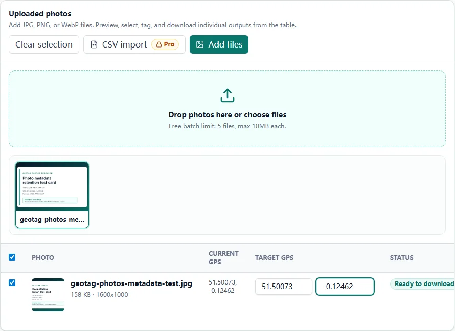
Choose JPG, PNG, or WebP files.
Use map, address search, or manual coordinates.
Download one image or a batch ZIP.
Before and after
The output records exactly what changed.
This example mirrors the browser workflow: read the original, apply a chosen coordinate, then verify the exported copy.
- GPS status: Not found
- Source file: Unchanged
- Location decision: Pending
- GPS status: Written
- Latitude: 40.758896
- Longitude: -73.985130
EXIF GPS checker
Not sure whether your photo already has GPS?
Use the checker first to read existing GPS coordinates, camera details, image size, and publishing metadata. If GPS is missing or incorrect, continue to the editor and download a tagged copy.
GPS found
Verify coordinates before publishing or delivering files.
No GPS
Open the editor and apply an exact map location.
Wrong GPS
Replace old metadata and download a clean tagged copy.
Related product · GetGeoVideo
Working with videos too?
For MP4 and MOV files, our separate product GetGeoVideo provides tools to check GPS metadata and add coordinates before delivery. Video files follow GetGeoVideo's processing and privacy policies.
Workflow
Geotag your images in four practical steps
The tool is built around how agencies and small teams actually deliver photo work: upload, locate, apply metadata, export proof.
Upload a batch
Drop JPG, PNG, or WebP files. Existing GPS metadata is read locally before anything is changed.
Set exact GPS
Use map click, address search, manual coordinates, shared batch location, or CSV import.
Apply metadata
Add title, description, keywords, author, copyright, resize, and watermark where needed.
Export proof
Download one tagged image directly, export a ZIP for batches, and generate a verification report for client delivery or internal QA.
Capabilities
A stronger geotag photo tool for local SEO workflows
GeoTag Photos works as a GPS EXIF editor, geotag image checker, metadata workspace, and client handoff tool. The focus is clean output and verifiable delivery, not exaggerated ranking claims.
GPS EXIF for JPEG
Write reliable latitude and longitude fields for the format most metadata viewers understand.
PNG and WebP metadata
Support modern image workflows while clearly marking compatibility limits.
Batch table editing
Review file status, original GPS, target GPS, format, and exceptions before export.
CSV import and reports
Match coordinates by filename and export proof with status, format, and compatibility notes.
Resize and watermark
Prepare lighter delivery files and add brand marks without leaving the browser.
Privacy-first processing
Original image files are processed locally; server routes handle accounts, limits, and geocoding.
Use cases
Built for agencies, photographers, and local businesses
Geotagging is useful when it fits a real preparation and delivery process. These workflows keep the product grounded.
Local SEO agencies
Prepare batches for multiple clients, apply exact business or job-site coordinates, and export proof files for internal QA or client delivery.
Photographers
Add clean GPS metadata after a shoot, protect images with copyright fields, and deliver geotagged copies without modifying originals.
Real estate and contractors
Organize property, project, storefront, and service-area photos by location before publishing or handing files to a marketing team.
Small business marketers
Prepare website and profile photos with accurate coordinates, readable descriptions, and consistent filenames before upload.
Compare
More than an upload, marker, download flow.
Basic geotaggers can write a location. GeoTag Photos adds the parts teams need after that: privacy clarity, format guidance, reports, CSV workflows, and batch review.
| Area | Basic tools | GeoTag Photos |
|---|---|---|
| Privacy model | Often unclear whether files are processed locally or uploaded. | Original photos stay in the browser; server routes never receive the image files. |
| Ranking language | Some tools imply geotagging alone can improve Maps rankings. | Honest local SEO framing: clean metadata and workflow proof, no ranking guarantees. |
| Verification | Download files, then manually check whether GPS was written. | Generate a report with filename, coordinates, format, status, and compatibility notes. |
| Format guidance | Lists supported formats without explaining compatibility limits. | JPEG is recommended; PNG/WebP are marked as partial compatibility; HEIC is detected. |
| Agency workflow | Single upload and download flow. | Batch table, per-file overrides, CSV import, shared coordinates, ZIP export, and presets. |
Formats
Clear format support, no guesswork
JPEG is the safest output for GPS EXIF. PNG and WebP support is useful, but platform visibility varies, so the app labels compatibility honestly.
| Format | Support | Best use |
|---|---|---|
| JPG/JPEG | Strong GPS EXIF support | Recommended for geotagged photos |
| PNG | Partial metadata compatibility | Reports and internal workflows |
| WebP | Partial EXIF compatibility | Modern web image workflows |
| HEIC | Detected, not processed in v1 | Convert to JPEG first |
Recommended workflow
- Upload photosRead existing EXIF GPS and detect unsupported files locally.
- Choose a locationSearch an address, click the map, or type coordinates manually.
- Apply metadataAdd title, description, keywords, author, and copyright fields.
- Export and verifyDownload a tagged image directly, export a ZIP for batches, and create a report for records or client handoff.
Pricing
Pricing for local SEO photo teams.
Start free with 5-image batches and 10 daily image exports. Pro includes 50-image batches, no daily export cap, CSV imports, reports, resize, watermark, and saved locations.
Free
For checking the workflow with small trial batches.
- 5 images per batch
- 10 exported images per day
- JPG/JPEG, PNG, and WebP support
- Max 10MB per image
- Manual coordinates and map click
- Basic metadata fields
- Small ZIP download
- 3 address/place searches per month after sign-in
- No ads
Pro Monthly
For recurring photo work, billed monthly.
- 50 images per batch
- No daily export cap
- Max 15MB per image
- 1000 address/place searches per month
- CSV coordinate import
- Verification report CSV
- Resize and watermark
- JPEG and WebP conversion
- Saved location presets
- Priority product support
Pro Annual
The same Pro features, billed annually.
- 50 images per batch
- No daily export cap
- Max 15MB per image
- 1000 address/place searches per month
- CSV coordinate import
- Verification report CSV
- Resize and watermark
- JPEG and WebP conversion
- Saved location presets
- Priority product support
Enterprise
For teams with custom process or billing needs.
- Custom batch and search limits
- Agency onboarding and workflow review
- Priority support for metadata compatibility
- Custom billing and procurement support
- Roadmap input for team workflows
FAQ
Questions before you geotag a batch
These answers are deliberately practical: format support, privacy, limits, Google Business Profile workflows, and verification.
What does it mean to geotag a photo?+
Geotagging a photo means adding latitude and longitude to the image metadata. For JPEG files this is usually stored in EXIF GPS fields, while PNG and WebP support depends on metadata chunks and platform compatibility.
Can I use GeoTag Photos for free?+
Yes. Free users can process 5-image batches, export up to 10 images per day, click the map, type coordinates, add basic metadata, download a tagged image directly, or export a small ZIP. Address search requires sign-in because it uses a server-side lookup. Pro is for 50-image batches, no daily export cap, CSV imports, reports, resize, watermark, saved locations, and higher search limits.
What counts as an address search?+
An address search is when you type a street address, business name, or place name and the app looks up coordinates for you. Clicking the map, dragging the marker, using current location, or typing latitude and longitude manually does not count as an address search.
What is CSV import used for?+
CSV import is for batches where different files need different coordinates. A Pro user can prepare a spreadsheet with filename, latitude, and longitude, then match those coordinates to uploaded images automatically. If every photo uses the same location, map click or manual coordinates are faster.
Is ZIP export a Pro feature?+
No. Direct image download and small ZIP export are available on Free within the 5-image batch and 10-daily-export limits. Pro increases the batch size, removes the daily export cap, and adds client-ready workflow features such as CSV coordinate import, verification report CSV, resize, watermark, and saved location presets.
Are my original photos uploaded to your server?+
No. Reading metadata, writing GPS coordinates, resizing, watermarking, ZIP export, and CSV report generation run in your browser. Server routes only handle account, usage, payment, address search, and optional location presets.
Which image format is best for geotagged photos?+
JPEG is the safest choice because GPS EXIF is broadly supported by photo tools and metadata viewers. PNG and WebP can carry metadata, but many platforms and operating-system viewers show partial support.
Does GeoTag Photos support HEIC?+
HEIC files are detected, but v1 does not write HEIC metadata. Convert HEIC photos to JPEG before geotagging when you need reliable GPS EXIF output.
Can I check existing GPS data before changing it?+
Yes. Uploading photos reads existing GPS metadata locally and shows whether each file already has coordinates. You can then keep the original location, override it, or batch apply a new one.
Can I geotag multiple photos with the same coordinates?+
Yes. Choose a map location or enter coordinates, then apply the same GPS location to the whole batch. Pro users can also import filename-matched coordinates from CSV.
Can I use it for Google Business Profile photos?+
You can use the tool to prepare photo metadata before a Google Business Profile or local SEO workflow. We do not claim that metadata alone guarantees rankings.
Does Google strip photo metadata after upload?+
Many platforms optimize displayed images and may remove visible metadata from resized public copies. That does not change the value of keeping clean source files, client handoffs, and internal verification reports.
What should I put in keywords and descriptions?+
Use plain, accurate descriptions of what appears in the image and where it is relevant. Avoid keyword stuffing. Good metadata should help humans understand the file, not just target search terms.
Can I use GeoTag Photos on mobile?+
Yes. The interface is responsive. Large batches are still more comfortable on desktop because image processing uses browser memory.
How do I get support?+
Email support@geotagphotos.app for account, billing, export, format compatibility, CSV import, or address search issues.
Photo EXIF GPS Checker
Free Chrome extension
Check a photo's GPS without opening another website.
Install the extension from the Chrome Web Store, choose one local photo, and see whether readable latitude and longitude are already present.
- JPG, PNG, and WebP
- No upload or account
- Zero browser permissions
GeoTag Photos
EXIF field instrument
Does this photo know where it was?
Read the GPS field in one photo. Nothing leaves your device.
Choose one photo
or drop it here
JPG · PNG · WEBP · ≤ 15MBNo upload, account, or site access required.