Photo EXIF GPS Checker for location metadata.
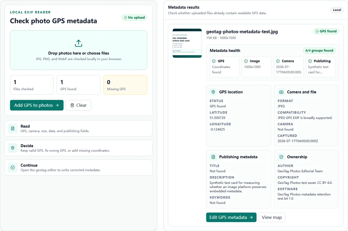
Check whether a photo is geotagged before you publish, deliver, or edit it. Find GPS coordinates, extract location metadata, and view camera, image, publishing, and copyright fields without sending the original image to our server.
Built for the decision users actually need: keep the GPS, correct it, or add a missing location.
Metadata results
Check whether uploaded files already contain readable GPS data.
Metadata results appear here
Upload a photo to see GPS status, camera details, dimensions, and publishing metadata.
Readable checker result
A sample result shows the decision-ready fields first.
Values appear only when they are present in the selected file; this example documents the result layout.
What it checks
A GPS-focused EXIF data viewer, not a raw metadata dump.
A generic EXIF viewer can expose hundreds of fields. This page prioritizes the fields that matter when you need to verify photo location metadata, prepare local SEO images, or hand off files to a client.
GPS location
See whether latitude and longitude are present, missing, or ready to verify.
Image summary
Review file format, dimensions, file size, and compatibility notes.
Camera EXIF
Check camera make, model, and capture date when the file includes them.
Publishing metadata
Inspect title, description, and keywords used in handoff workflows.
Ownership fields
Read author, copyright, and software fields where available.
Next action
Move directly from checking to adding or correcting GPS metadata.
Find photo geotags
Find, view, and extract photo geotags from metadata.
The checker is built for the specific location questions people ask before publishing, delivering, or editing a file: is this photo geotagged, what coordinate is inside it, and what should happen if GPS is missing?
Check if a photo is geotagged
Upload a photo and review the GPS status. The checker separates files with readable coordinates from files with missing or malformed location metadata.
Extract GPS coordinates from EXIF
When a file includes readable GPS fields, the checker extracts latitude and longitude and shows the coordinate in a map-ready format.
Understand when location cannot be identified
If a photo has no readable GPS metadata, the checker does not guess from pixels. Use visible context, the original library, or a trusted record before adding a location.
Workflow
How to check whether a photo has GPS metadata.
The checker is designed around a practical verification flow: read first, decide second, edit only when needed.
Built for verification and correction
The checker puts GPS status first, then gives a clear path to fix missing or inaccurate coordinates without changing the source file.
Generic EXIF viewer
- Shows many raw fields
- Often stops after inspection
- May not explain format compatibility
GeoTag Photos checker
- Highlights GPS status first
- Shows readable metadata groups
- Links directly to GPS editing
Formats
Supported image formats for GPS metadata checks.
Metadata support is not equal across image formats. The page states the practical compatibility instead of overpromising.
| Format | Support | Best use |
|---|---|---|
| JPG / JPEG | Best support | Best choice for reliable GPS EXIF verification and geotagged client delivery. |
| PNG | Partial metadata support | Can contain metadata, but many viewers show only part of it. |
| WebP | Partial EXIF support | Useful for web workflows, but metadata visibility varies by platform. |
| HEIC | Detected only | Convert to JPEG before geotagging when you need dependable GPS EXIF output. |
Internal links that match user intent
Need to check a video?
This checker supports photos. For MP4 or MOV files, check video GPS metadata with GetGeoVideo, our separate video tool. Its processing and privacy policies apply to video uploads.
Use cases
When to use a photo location metadata checker.
Use the checker before trusting, publishing, delivering, or modifying an image with location metadata.
Before editing GPS
Confirm whether the photo already has a usable location before replacing metadata.
Before client handoff
Open a finished image and verify that the exported file still contains readable GPS data.
Before local publishing
Check source files before using them in a Google Business Profile or local SEO workflow.
GeoTag Photos treats geotagging as metadata preparation and verification. It does not promise ranking improvements from metadata alone. For more context, read the Google Business Profile photo geotagging workflow.
FAQ
Photo EXIF GPS checker questions
Short answers for the decisions users usually need to make after checking a photo.
What is a Photo EXIF GPS Checker?+
A Photo EXIF GPS Checker reads image metadata to show whether a photo contains GPS latitude and longitude. It helps you verify location metadata before publishing, sending files to a client, or adding corrected coordinates.
Can I check photo GPS metadata for free?+
Yes. Upload a JPG, PNG, or WebP image and the checker reads available GPS, camera, image, and publishing metadata locally in your browser.
How do I check if a photo is geotagged?+
Upload the photo to the checker and review the GPS status. If readable latitude and longitude are present, the photo is geotagged. If GPS is missing or malformed, the checker marks the file so you can add or correct coordinates.
Can I identify a location from a photo without GPS metadata?+
Not reliably from metadata alone. If a photo has no readable GPS coordinates or location fields, the checker cannot infer where it was taken. Use visible context, the original camera or phone library, or a trusted project record before adding a location.
Can I extract a geotag from a photo?+
Yes, when the file contains readable GPS metadata. The checker extracts latitude and longitude from the photo metadata and shows them as coordinates. If no GPS fields are present, there is no geotag to extract.
How do I find the geotag on a photo?+
Upload the image and review the GPS location section. If the photo has a readable geotag, the checker shows latitude and longitude and gives you a map link for the coordinate.
Is this a geotag photo viewer?+
Yes. It is a GPS-focused geotag photo viewer for checking location metadata, camera fields, file details, publishing fields, and ownership information without showing every raw EXIF tag.
Are my photos geotagged?+
Upload one photo or a small batch and the checker counts GPS found and missing GPS files. Use those results to decide whether to keep the location, fix wrong GPS, or add missing coordinates.
Are my photos uploaded to your server?+
No. The checker uses browser-side processing. Your original images do not need to be uploaded to our server to read EXIF GPS metadata.
What metadata can I see?+
The checker shows GPS status, latitude, longitude, camera make and model, capture date, image dimensions, title, description, keywords, author, copyright, and software fields when those values are available.
What if my photo has no GPS metadata?+
The checker marks the file as No GPS. You can then open the geotag editor, choose a location on the map, type latitude and longitude, or use address search, then download a tagged copy.
Can I edit wrong GPS coordinates?+
Yes. If the checker finds GPS coordinates that are incorrect, open the geotag editor and replace them with the correct map location or manual latitude and longitude.
Which image formats work best?+
JPEG is the most reliable format for GPS EXIF workflows. PNG and WebP can carry metadata, but viewer and platform support varies. HEIC is detected, but v1 does not write HEIC GPS metadata.
Can I use this before Google Business Profile or local SEO publishing?+
Yes. Use the checker to verify whether photos already contain readable GPS metadata before a local SEO or Google Business Profile publishing workflow. GeoTag Photos does not claim that metadata alone guarantees rankings.